The problem
Some organization’s working with spatial data are still relying on fragmented, one-off scripts.
Data is pulled from multiple sources.
Formats vary.
Coordinate systems don’t align.
And each new analysis often starts from scratch.
The result?
- Inconsistent outputs
- Manual rework
- Limited reproducibility
- Reduced confidence in results
For teams working in risk, planning, or public safety, that introduces unnecessary uncertainty into decision-making.
A practical approach
There’s no single “right” way to build spatial workflows.
Different tools, environments, and constraints will always influence the approach.
But strong workflows tend to share a few characteristics:
- Structured
- Repeatable
- Transparent
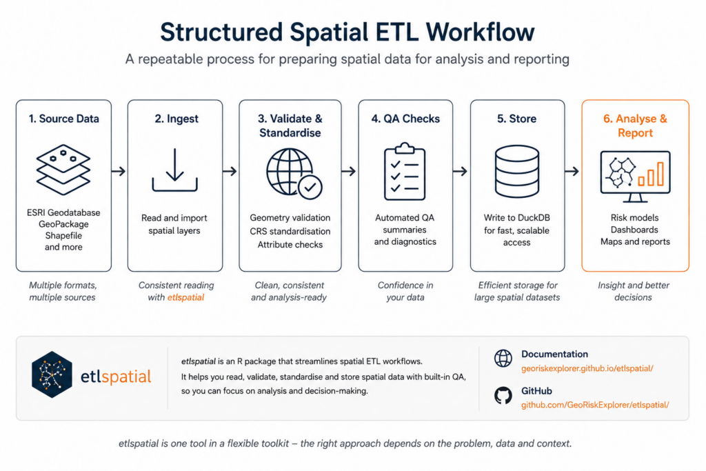
To support that, I developed etlspatial — a lightweight framework in R that standardises common spatial ETL tasks where it makes sense.
It’s not intended to replace other tools.
It provides a consistent backbone for spatial data preparation.
What this does well
etlspatial focuses on the parts of the workflow that are often the most inconsistent:
- Reading spatial data from ESRI geodatabases and GeoPackages
- Validating and normalising geometry for the current processing context
- Standardising coordinate reference systems (CRS)
- Writing structured outputs to DuckDB
- Running built-in QA checks to support confidence in outputs
Used appropriately, it helps reduce variation between runs and across projects.
A simple example
At its core, the workflow stays intentionally simple:
sa4 <- read_esri_layer(...)
qa_spatial_summary(sa4)
The aim isn’t to hide complexity—but to remove repetition and improve consistency.
Where this fits in practice
This approach has been applied as part of broader spatial analytics workflows, including:
- Visitor safety reporting systems
- Spatial risk modelling and hotspot analysis
- Multi-source geospatial ETL pipelines
- Data preparation for dashboards and executive reporting
In these environments, etlspatial is one component within a wider toolkit—supporting consistent data preparation alongside other analytical methods.
Explore the package
- Documentation: etlspatial pkgdown site
- GitHub repository: etlspatial on GitHub
About GeoRisk Analysis
GeoRisk Analysis focuses on spatial risk analytics, combining GIS, data science, and structured risk frameworks to support better decision-making.
The focus is always on selecting the right approach for the problem—whether that involves custom workflows, existing tools, or lightweight frameworks like etlspatial.