Spatial risk analysis workflows are often fragmented across GIS software, spreadsheets, manual processing steps, and custom scripts. While these approaches can produce useful outputs, they can also create challenges around reproducibility, quality assurance, transparency, and long-term maintenance.
To help address these issues, GeoRisk Analysis has been developing riskworkflowr — an open and evolving R package focused on reproducible spatial risk analysis workflows.
The package is designed to support practical spatial analytics using modern R spatial tooling, with a focus on transparent workflows, repeatable analysis, and scalable spatial processing.
Why Reproducible Spatial Workflows Matter
Spatial analysis frequently involves multiple interconnected processing steps, including:
- spatial joins and assignment,
- event aggregation,
- rate calculations,
- risk metrics,
- spatial indexing,
- and cartographic visualisation.
Without structured workflows, analysis can become difficult to validate or reproduce over time. Small differences in processing logic, spatial assignment methods, or aggregation rules can lead to inconsistent outputs and reduced confidence in results.
riskworkflowr aims to support more defensible and repeatable spatial analysis pipelines by combining practical GIS workflows with reproducible analytical approaches in R.
What riskworkflowr Does
The package currently supports workflows including:
- spatial assignment and joins,
- areal unit analysis,
- event aggregation and summarisation,
- risk metrics and rate calculations,
- Standardised Morbidity Ratio (SMR) analysis,
- H3 hexagonal spatial workflows,
- and choropleth risk mapping.
The package is designed to work alongside modern spatial tooling in R, including sf, dplyr, ggplot2, and H3 spatial indexing approaches.
While still evolving, the package is intended to support practical applications across areas such as visitor safety, environmental risk, infrastructure and asset analysis, public health, emergency management, and broader spatial decision support.
Why H3 Spatial Indexing?
Traditional administrative boundaries are useful for many forms of analysis, but they can introduce limitations due to inconsistent polygon shapes and sizes.
riskworkflowr includes support for H3 hexagonal workflows, allowing spatial analysis to be performed using consistent spatial units across multiple resolutions.
This can assist with scalable aggregation, multi-resolution analysis, comparative spatial assessment, and more flexible spatial modelling workflows.
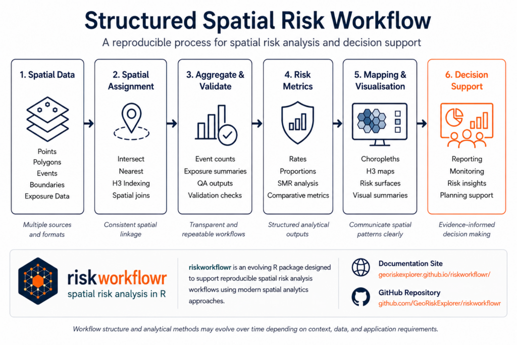
Example Spatial Risk Workflow
The figure below illustrates a simplified workflow structure supported by riskworkflowr.
Documentation and Examples
The project now includes a dedicated documentation website built using pkgdown, including structured workflow articles, reference documentation, practical examples, and project update notes.
This helps make the package more accessible for analysts, GIS practitioners, and organisations exploring reproducible spatial analysis approaches in R.
Explore the project:
Looking Ahead
riskworkflowr will continue evolving over time as additional workflows, analytical methods, and spatial tooling are refined and expanded.
The broader goal remains simple: supporting practical, transparent, and reproducible spatial risk analysis workflows that can assist real-world decision making across multiple domains.